Forum
- Home
- Forum
Notifications
Clear all

Topic starter
We in the US are experiencing a profound drought in the western half of the country and the federal government is doing next to nothing about it, instead it spends billions on pet globohomo political projects like this Ukraine thing.
All the mega engineering projects White Americans put in place in the 20th century to prevent the natural cyclical drying out of the region from being a major problem are decaying through lack of maintenance and haven't been upgraded. The Colorado River, source of water for irrigation of crops that feed tens of millions in the US Southwest and beyond and producer of the of the billions of megawatts of electricity that once powered the development of our West is drying up and "official" climate science blames it all on 'global warming' which we can mitigate by buying into the 'science' of their comically twisted neoliberal agenda.
Graph showing the drought based on Nasa satellite data
US Groundwater storage as of 12/20

This is one of top evolving existential threats to the people of North America, and it wont be solved by the narcissistic jewish cultists who run the fedgov, regardless of how many movies they and their friends produce in hollywood showing them saving the world from drought.
Nasa's kite on this event (and the page I linked to for the images) shows the degree of their denial about what is really happening in the first sentence ...the drought just "flared up" on 2020? The situation has been steadily getting worse for almost two decades ....
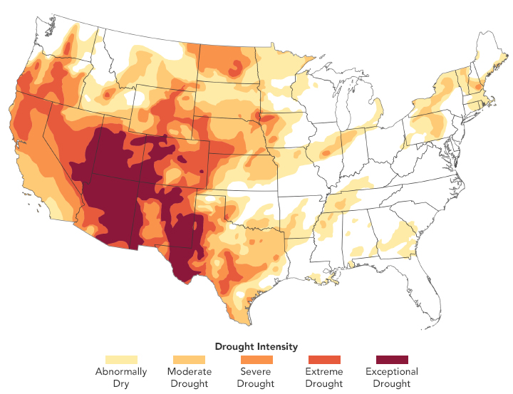
A drought that flared up in the western United States in spring 2020 has expanded and intensified across the summer and fall. In August, a third of the United States was experiencing at least a moderate level of drought. By December, roughly half of that area was, with about 33 percent facing what the U.S. National Drought Monitor classifies as “extreme” or “exceptional drought.” Initially, Colorado, Utah, Nevada, and northern California faced the most severe conditions. Over the summer and fall, the drought intensified in Arizona and New Mexico and spread onto the Great Plains and Texas.
The map above, built with data from the Drought Monitor, depicts areas of drought in progressive shades of orange to red on December 8, 2020. It is based on measurements of climate, soil, and water conditions from more than 350 federal, state, and local observers around the country. NASA provides experimental measurements and models to this drought monitoring effort.
“Compared to late 2019 and early 2020, when there was very little drought in the continental United States, this is quite an extreme single-year event that developed rapidly over the course of 2020,” said Benjamin Cook, a climate scientist at NASA’s Goddard Institute for Space Studies. “But if you look over longer time scales, I would argue this is really a continuation of a multi-decadal event that began around 2000. There have been some breaks, but the Southwest has been in more-or-less continuous drought conditions since then.”
The consequences of the unusually dry and warm temperatures in 2020 have shown up in a variety of ways. Several states, particularly California, have endured unusually active and destructive fire seasons. Some farmers have already seen—or anticipate—poor yields as they struggle with a lack of water for crops and livestock. Reservoirs, lakes, and streams in several areas are reaching unusually low levels.
This map depicts shallow groundwater storage in the continental U.S. as of December 7, 2020, as measured by the Gravity Recovery and Climate Experiment Follow On (GRACE-FO) satellites. The colors depict the wetness percentile; that is, how the levels of groundwater compare to long-term records for the month. Blue areas have more abundant water than usual, and orange and red areas have less. The darkest reds represent dry conditions that should occur only 2 percent of the time (about once every 50 years).
“The Southwest monsoon was underwhelming this year, and many places in that region rely on that precipitation as part of their water budgets,” said Christopher Hain, a research meteorologist at NASA’s Marshall Space Flight Center. “Given the La Niña happening now, there is a higher-than-normal chance that winter rains will not help much and below-average precipitation will further exacerbate the drought. That could set the stage for even worse conditions next spring, summer, and fall.”
La Niña—cooler than normal sea-surface temperatures in the central and eastern tropical Pacific Ocean—tends to cause dry weather in the Southwest U.S. The associated weather patterns push the jet stream north and cause it to curve, driving storms to the Pacific Northwest and the Great Plains instead.
“The long-term, multi-decadal drought is largely driven by precipitation deficits connected to persistently cold sea surface temperatures in the eastern tropical Pacific—in essence a string of years with long-lasting and intense La Niñas,” said Cook. “However, there is strong evidence from climate models and centuries of tree ring data that suggest about one-third to one-half of the severity of the current drought can be attributed to climate change.”
:rofl
https://earthobservatory.nasa.gov/images/147655/the-drying-us-west
A. Linder @Alex_Linder@pieville.net
A White nation would no doubt establish Camps for Anime Respecters. Hard word, after all, cures anime fandom, just like sexual aberration.
Posted : 17/06/2022 8:45 am